


Day 1 of Summer School ✅☀️
From additional phonics and reading comprehension practice to mastering column addition, our children worked incredibly hard and impressed us every step of the way. We even found time to visit our much-loved rabbits, Salt and Pepper, for some well-earned cuddles and smiles. 🐇🤍
We can’t wait to see what the rest of the week has in store! 🌈📚✨
✨ That’s us… over and out for 2025–2026. 💙
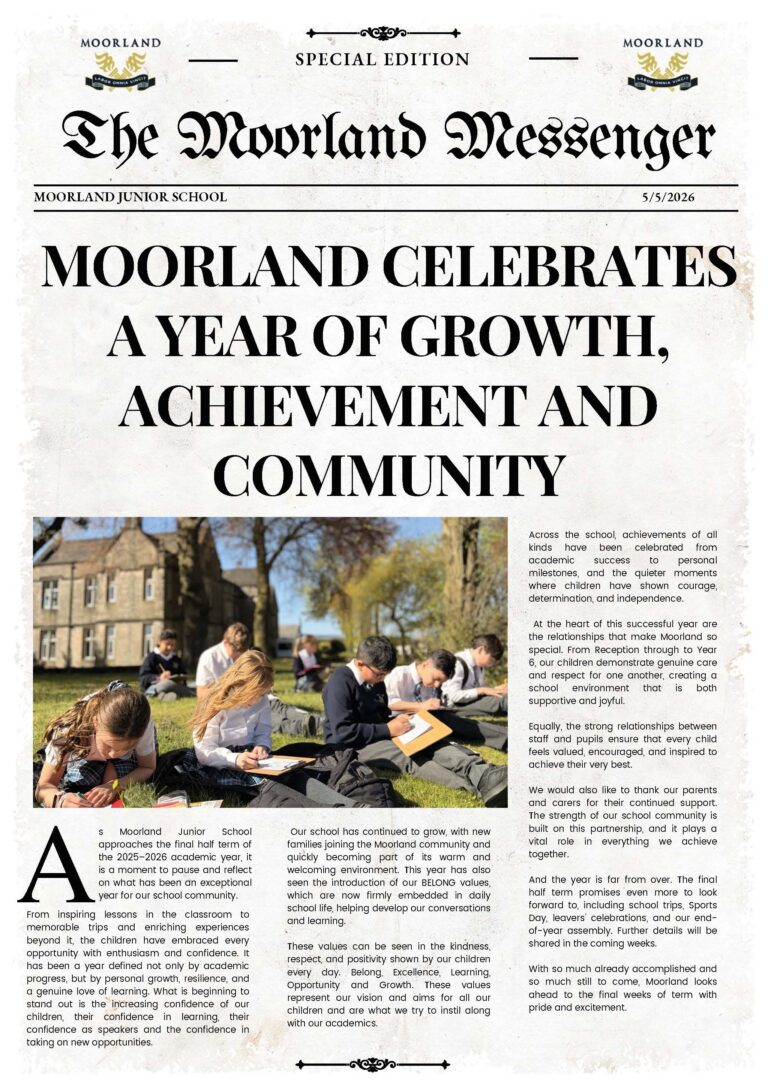
What a year it has been.
Our children have surpassed expectations, achieved incredible things and made us proud every single day. They have worked so hard, tackled every challenge with determination and done it all with smiles on their faces.
This year we’ve visited Paris, expanded our Forest School, welcomed new families, grown as a school community and created memories that will stay with us for years to come.
To our wonderful parents - thank you from the bottom of our hearts for trusting us with your precious children. Your support means everything to us.
Moorland truly is one big family, and we are so grateful for every single one of you.
Today has been one of the most wholesome, emotional days of the year. We’ve shed tears as we’ve said goodbye to our incredible Year 6 children, celebrated everything they’ve achieved, and listened to parents sharing memories filled with love and pride. We know each and every one of them is ready for their next adventure, taking with them the confidence, skills and values they’ve developed during their time at Moorland.
Whilst the school year may be over, we’re not quite finished yet… 👀 Keep your eyes peeled for highlights from our wonderful Year 6 Leavers’ Meal.
Here’s to an unforgettable 2025–2026… and to all the exciting opportunities that await in 2026–2027. 💙
✨ That’s us… over and out for 2025–2026. 💙
What a year it has been.
Our children have surpassed expectations, achieved incredible things and made us proud every single day. They have worked so hard, tackled every challenge with determination and done it all with smiles on their faces.
This year we’ve visited Paris, expanded our Forest School, welcomed new families, grown as a school community and created memories that will stay with us for years to come.
To our wonderful parents - thank you from the bottom of our hearts for trusting us with your precious children. Your support means everything to us.
Moorland truly is one big family, and we are so grateful for every single one of you.
Today has been one of the most wholesome, emotional days of the year. We’ve shed tears as we’ve said goodbye to our incredible Year 6 children, celebrated everything they’ve achieved, and listened to parents sharing memories filled with love and pride. We know each and every one of them is ready for their next adventure, taking with them the confidence, skills and values they’ve developed during their time at Moorland.
Whilst the school year may be over, we’re not quite finished yet… 👀 Keep your eyes peeled for highlights from our wonderful Year 6 Leavers’ Meal.
Here’s to an unforgettable 2025–2026… and to all the exciting opportunities that await in 2026–2027. 💙
🌊🐠 Under the Sea Summer Fayre 2026 🐙🪸
A huge thank you to our wonderful PTA for yet another exceptional Summer Fayre! 💙
Events like these take an incredible amount of planning, organisation and hard work, they simply wouldn’t be possible without the dedication and support of our amazing PTA volunteers.
Thank you to everyone who helped, donated, volunteered and attended, together we’ve made another fantastic afternoon full of fun and memories for our children.
🐟 Costume prizes will be presented during Friday’s Celebration Assembly at 2:30pm. We can’t wait to see our winners!
Also a huge thank you to @littlevoicesbdrv for preparing our children for a fantastic performance, showing off their LAMDA skills.
#makingmemories #SummerFayre #UnderTheSea #SchoolCommunity #PTA
Wellbeing night with the team 🧘♀️🐐
Yoga, laughter, fresh air and a few unexpected goat interruptions… exactly what we needed!
The best kind of team time 💛
Goat yoga @mrsdowsons
Wellbeing night with the team 🧘♀️🐐
Yoga, laughter, fresh air and a few unexpected goat interruptions… exactly what we needed!
The best kind of team time 💛
Goat yoga @mrsdowsons
What a fantastic afternoon celebrating our 2026 Sports Day. ❤️🏅🏃♀️
The children were amazing from start to finish…
And yes… the teachers may have got a little competitive too! 😂 Wait for the surprise teachers’ race at the end!
What a fantastic afternoon celebrating our 2026 Sports Day. ❤️🏅🏃♀️
The children were amazing from start to finish…
And yes… the teachers may have got a little competitive too! 😂 Wait for the surprise teachers’ race at the end!
☀️💦 Beating the heatwave the Moorland way! 💦☀️
What a fantastic afternoon we’ve had making memories in the sunshine!
Days like these remind us what makes our school so special - a place where children can learn, play, laugh and make memories together.
We absolutely love our school! 💙
#HeatwaveFun #WaterFun #SchoolLife #MakingMemories #WeLoveOurSchool
Learning comes to life outside the classroom! 🌿💦
Our Years 3 and 4 had an amazing day at Cuerden Valley becoming real geographers and scientists. They explored the river, identified insects and river wildlife, measured the width and depth of the river, investigated how clean the water is, and learned all about key river features including meanders, deposits and the mouth of a river.
There was plenty of hands-on learning (and a lot of splashing!) as the children immersed themselves in their field study experience. 🌍🦋🐟
#MoorlandSchool #FieldStudy #LearningOutsideTheClassroom #Geography #Science
Happy Father’s Day to all our wonderful dads, grandads, uncles and the special father figures in our children’s lives. 💙
A huge thank you to everyone who joined us on Friday for breakfast.
From all of us at Moorland Junior School, we wish you a Happy Father’s Day! 💙 #Fathersday
Happy Father’s Day to all our wonderful dads, grandads, uncles and the special father figures in our children’s lives. 💙
A huge thank you to everyone who joined us on Friday for breakfast.
From all of us at Moorland Junior School, we wish you a Happy Father’s Day! 💙 #Fathersday